Background on the Delaware Coastal Flood Monitoring System
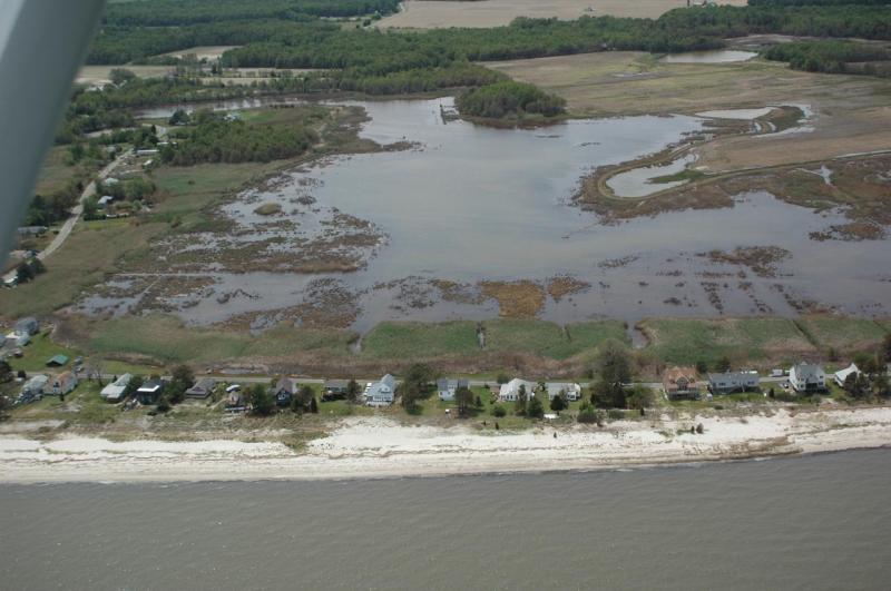 Kitts Hummock after the Mother's Day Storm, May 2008
In the last two decades storms such as Hurricanes Katrina and Ike along the Gulf of Mexico and Isabel and Sandy along the Atlantic Coast of the United States have resulted in significant loss of life, injuries and property damages reaching well over $100 billion, much of it due to severe coastal flooding. The Delaware coastline is extremely vulnerable to such events and has been affected by many great storms in its history, particularly the Ash Wednesday storm in March of 1962 and the Mother’s Day storm on May 12, 2008, which left at least one person dead and many people homeless after ocean flood waters destroyed homes, especially along the Delaware Bay Coast of Kent County. The added concern of sea-level rise and its effect on the frequency and intensity of coastal flooding events, have further emphasized the need for a modern, dependable coastal flood monitoring and warning system for Delaware’s coastal communities.
The Delaware Coastal Flood Monitoring System (CFMS) has been developed, jointly by the Delaware Geological Survey (DGS) and the Delaware Environmental Observing System (DEOS) at the University of Delaware, to achieve such a goal. A prototype of the system was released in the summer of 2011 for a limited number of Kent County communities along the Delaware Bay but has since expanded to include coastal areas from the City of New Castle southward to the City of Lewes (i.e., areas within the coastal plain of Delaware where flood risk is dominated by tidal fluctuations, wind-driven storm surge and waves.)
The CFMS serves three primary objectives:
- To send out warning alerts, via text or email, to community members up to 48 hrs in advance of potential flood conditions.
- To provide access to current, real-time tidal and related meteorological and hydrologic conditions.
- To provide local, community-based tidal+surge predictions, with potential flood inundation maps and road elevation profiles.
How the Delaware CFMS works
The Delaware Coastal Flood monitoring System works basically through the following steps:
- Ingest NOAA DBOFS operation model forecasts fields of water level surface for the Delaware Bay. Extract the predicted values for each hour for the next 48 hours for each coastal community included in the CFMS. (See list of communities below.)
- Send out (email or text message) alerts to subscribers if the water level is forecasted to be larger than their alert threshhold. This is done on a per community basis.
- Determine the maximum forecasted water level over the next 48 hours along the Delaware coast. Display this information on the CFMS home page via color gradient map and bar chart. These data show quickly the regions that are forecasted to receive the largest surge and by how much over MHHW.
- For each community, generate a flood inundation "potential" map. The map is generated by assuming a the water level at the coast is projected inland to the community region and comparing that to the DEM elevation. This is typically called a "bathtub" model as the water depth is based on a constant water level surface, analogous to filling a bathtub. We use the term "potential" as this method tends to over-estimate the inundated areas.
- In addition to generating the flood inundation map for a community, also create a time series of forecasted tidal predictions.
- Likewise, overlay the maximum forecasted water level for a community on road elevation profiles for transportation routes in the area. These routes were selected because they were either a DelDOT designated evacuation route during times of coastal flooding or a typically heavily trafficked road. Between 1 and 3 roads were selected for each community.
- Provide users with additional educational resources. These resources should facilitate the understanding of the data displayed by the CFMS by providing links to additional data sources or explanations of hydrologic terms and processes.
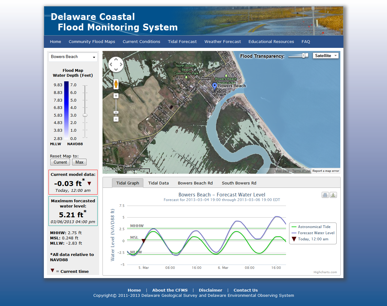 Flood inundation map example for Bowers Beach
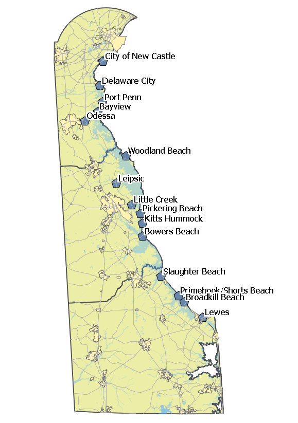
Coastal Communties
The current version of the CFMS includes the coastal communities from the City of New Castle down to the City of Lewes. There were 15 communities identified in this area (see accompanying figure), approximately one location for every 3 miles of coastline. Each community is listed on the CFMS home page with its maximum forecasted water level as well as a community map page with 48-hours tidal forecasts and road elevation profiles.
Each community also has configurable alerts, which means a user can set a threshhold value for any one of these communities and will receive an email or text message alert if a forecasted water level value crosses their threshhold. The method for setting up the forecast alerts is online and managed by DEOS, in a similar way to its real-time observation alerts. To receive an alerts account, contact DEOS at coastal-flood@udel.edu.
The 15 communities included in the current version of the CFMS are:
- City of New Castle
- Delaware City
- Port Penn
- Bayview
- Odessa
- Woodland Beach
- Leipsic
- Little Creek
- Pickering Beach
- Kitts Hummock
- Bowers Beach
- Slaughter Beach
- Primehook/Shorts Beach
- Broadkill Beach
- City of Lewes
 Flood inundation map example for Bowers Beach
Data Sources
Water Level Forecasts
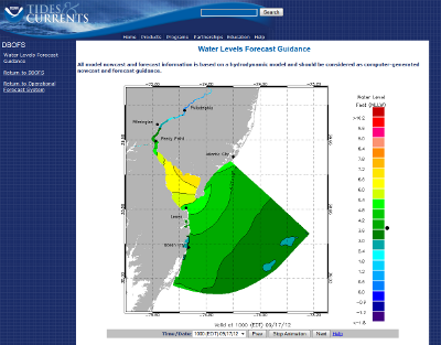 Example DBOFS Field Forecast
The coastal water level forecasts are imported from the NOAA Delaware Bay Operational Forecast System (DBOFS.) Model runs are performed every 6 hours. Forecasts are made for each hour out to 48 hrs in adavance. The spatial resolution of the DBOFS model various from 100 meters (near the upper Delaware River) up to 3 km (in the near-shore Atlantic Ocean.) Forecasted water levels made along the coast are projected inland.)
Digital Elevation Model (DEM) Data.
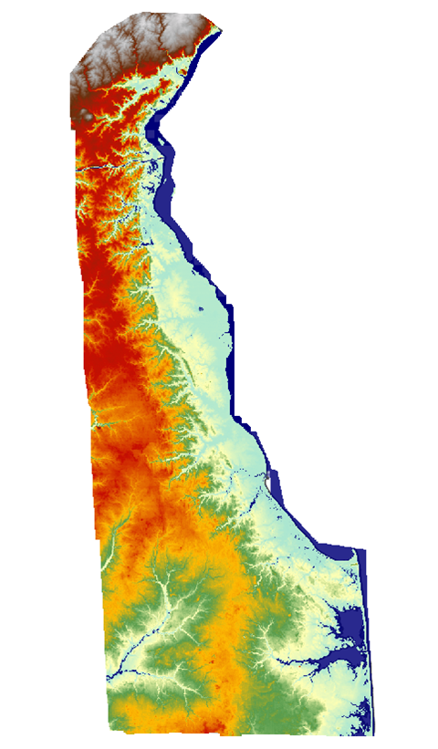 Delaware Statewide 2-meter DEM
Land-based elevation (topographic) datasets were recently produced for Delaware based on LIDAR. Sussex County was collected in 2005 through a contract with the U.S. Geological Survey and NASA to collect lidar using NASA’s Experimental Advanced Airborne Research Lidar (EAARL) system. New Castle and Kent Counties were collected in 2007 through a contract with Sanborn as part of their orthophotography acquisition. In 2009, DNREC Coastal Programs gathered up all mass point data for the 3 counties and sent them to NOAA Coastal Services Center for re-processing as a statewide 2-meter grids. Accuracy of the mass points meets or exceeds FEMA Accuracy standard for use in flood mapping and remapping work. In New Castle and Kent Counties, 18.5 cm RMSE for well defined points, 37.5 cm for heavily vegetated areas. In Sussex County, 15 cm RMSE.
Tidal Parameters
 VDatum Screenshot
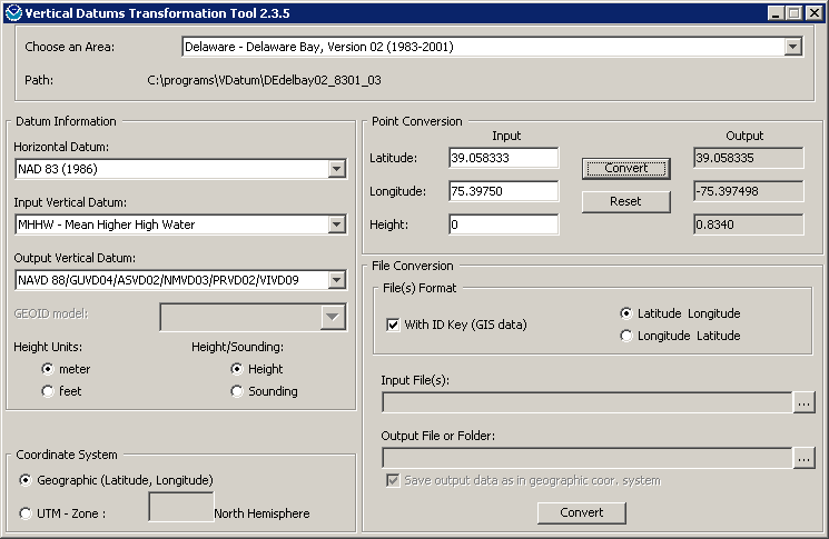
Tidal parameters (e.g., MHHW, MLLW, MSL) for each community were provided by the NOAA VDatum software package (http://vdatum.noaa.gov/). From the NOAA website, "VDatum is designed to vertically transform geospatial data among a variety of tidal, orthometric and ellipsoidal vertical datums - allowing users to convert their data from different horizontal/vertical references into a common system and enabling the fusion of diverse geospatial data in desired reference levels."
Audience
The targeted audience for the CFMS is state, county, and local emergency management personnel, researchers, planners, and others involved in the preparation and planning for severe flooding events. The CFMS is used by several state agencies including the Delaware Department of Natural Resources and Environmental Control (DNREC), the Delaware Emergency Management Agency (DEMA), the Delaware Department of Transportation (DelDOT), and the Delaware National Estuarine Research Reserve (DNERR). Moreover, the proposed system will have a direct impact upon the well-being of Delaware's coastal communities.
Support
Development and operation of the system builds on the existing expertise of the staff of the Delaware Environmental Observing System and the Delaware Geological Survey and is being conducted in cooperation with Delaware Coastal Program Section, DNREC.
This project was funded, in part, through grants from the DNREC Delaware Coastal Management Program (DCMP) and the Delaware National Estuarine Research Reserve (DNERR) with funding from the Office of Ocean and Coastal Resource Management, National Oceanic and Atmospheric Administration (NOAA) under award numbers NA09NOS4190172 and NA10NOS420018.
Documents
Presentation at the 2013 Delaware Estuary Science and Environmental Summit